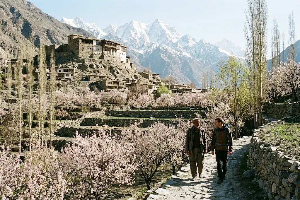
The best time to visit Hunza is mid-April to mid-October. Apricot and cherry blossom fills the valley from late March to mid-April, summer brings warm days and open high roads, and October turns the poplars gold. Winter is quiet and very cold, with some roads and flights interrupted by snow.
Hunza is a high valley in Gilgit-Baltistan, in Pakistan's far north, on the Karakoram Highway between the Karakoram mountains and the Chinese border. It is known for its forts, its orchards, peaks such as Rakaposhi and Ultar Sar, and for people who speak Burushaski, Wakhi and Shina in villages a few kilometres apart.
When to go, season by season
| Season | Months | What it's like |
|---|---|---|
| Blossom | Late March to mid-April | Apricot and cherry trees in flower, cool days, cold nights, quieter roads |
| Summer | May to August | Warm in the valley, the busiest time; best for glaciers, high meadows and the Khunjerab Pass |
| Autumn | September to October | Clear skies, gold poplars and harvest; many travelers' favourite |
| Winter | November to March | Freezing nights, snow on the passes, few visitors; some guesthouses close |
Pakistani school holidays and long weekends fill hotels in summer, so book ahead for June to August.
How to get there
By air: flights run between Islamabad and Gilgit, about an hour over the mountains. They operate only in clear weather and are often cancelled or delayed, so leave a spare day in your plans. From Gilgit it is a 2.5 to 3 hour drive to Karimabad, the main town in central Hunza.
By road: the Karakoram Highway (KKH) runs from Islamabad to Gilgit and on through Hunza to the Khunjerab Pass. Most people break the drive into two days, stopping in Besham, Chilas or Naran (when the Babusar Pass is open in summer). Landslides can close the road for hours or days, especially during the monsoon and spring melt, so a local driver who knows current conditions is worth having.
What to see
- Baltit Fort: the old seat of Hunza's rulers above Karimabad, roughly 700 years old and restored as a museum. Plan two to three hours for the fort and the old lanes around it.
- Altit Fort: older than Baltit, on a cliff above the Hunza River, with a royal garden and a restored village beside it.
- Eagle's Nest, Duikar: a viewpoint above Karimabad for sunrise and sunset over Rakaposhi, Ladyfinger and the valley.
- Attabad Lake: a turquoise lake formed in 2010 when a landslide blocked the Hunza River. Tunnels now carry the KKH around it; boats run in summer.
- Passu and the Passu Cones: the jagged peaks of the "cathedral" range in Gojal (upper Hunza), with the Hussaini suspension bridge and glacier walks nearby.
- Khunjerab Pass: the border with China at about 4,700 m, one of the highest paved border crossings in the world, inside Khunjerab National Park. Since December 2024 the pass has been kept open year-round for trade and travel, but winter weather can still close it.
Do foreigners need a permit?
Most travelers need only a Pakistan visa (most nationalities can apply online) and their passport. Sources agree that central Hunza and the Karakoram Highway up to Khunjerab don't need a special permit; you may be asked to register at police or army checkposts, so keep passport copies handy. Some areas near borders and certain treks in Gilgit-Baltistan need a No Objection Certificate (NOC) or a trekking permit arranged through a licensed operator. Rules change, so check with a local guide or operator before you go, and read your government's travel advice for Pakistan.
Why go with someone local
Hunza is easy to love on your own, but a local adds what you can't find in a guidebook: which family's orchard to walk through, where to eat chapshoro (meat-filled bread) and apricot soup, which jeep road is open after a landslide, and how to visit a village respectfully. Local guides and drivers also know the checkposts, the weather on the passes and the alternatives when a flight is cancelled.
Practical notes
- Money: cash in Pakistani rupees is essential; ATMs exist in Karimabad and Aliabad but can run out or go offline.
- Connectivity: mobile data works in the main valley; expect gaps higher up.
- Dress and respect: Hunza is welcoming and relatively liberal, but modest clothing (covered shoulders and legs) is appreciated, especially in villages. Ask before photographing people.
- Altitude: Karimabad is about 2,500 m; Khunjerab is about 4,700 m. Go up slowly and drink water.
The short version
- Go from mid-April to mid-October: April for blossom, October for colour.
- Fly Islamabad to Gilgit if the weather allows, or take two days on the Karakoram Highway.
- See Baltit and Altit forts, Attabad Lake, Passu and the Khunjerab Pass.
- Leave a spare day for weather and roads.